Using Google Earth
Google Earth is a popular and fun way to view geographic data. For this reason, maps of the UK�s Prominent Peaks are downloadable for use with Google Earth. These maps, however, are no substitute for using Ordnance Survey or equivalent maps of the hills for planning actual ascents. This page gives a simple guide to viewing the maps but for more details use the Google Earth user guide.
Finding Maps
The map finder page can be a starting point to help you find any Google map for the UK Prominent Peaks. This page can help you find wide area and local maps and launch them using Google Earth.
Alternatively, a set of zipped wide area and local area map files may be obtained from the downloads page and stored on your own computer. Firstly, extract the map files from the zip archive. Then if Google Earth is installed on your computer, you can open the maps by double clicking on a .kmz file.
For example we could open map 17.
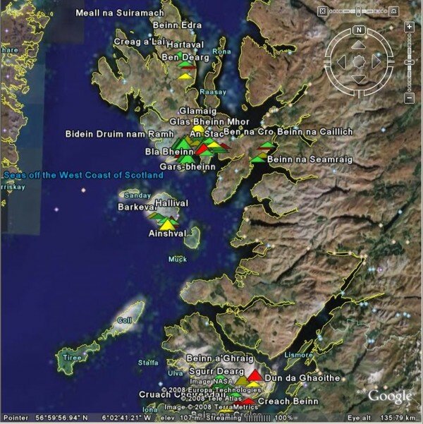
Map 17 is displayed in a similar way to the satellite view in Google Maps, but there are important differences. There is a different navigation control in the top right of the map (note that the navigation control may vary depending on your Google Earth version). At the bottom left, latitude and longitude are shown. The elevation of the cursor location is shown and there is an �eye altitude� displayed at the bottom right.
While Google Maps does not display the name of peaks unless they are clicked, Google Earth displays names and they may be difficult to interpret in the initial view.
Navigating
The navigation control allows panning, zooming, tilting and rotating of maps. The navigation control will depend on the Google Earth version you are using. See the Google Earth user guide for information on how to use the current control.
Suppose that we want to take a look at the Cuillin area on Skye. The map can be panned so that the area is at the centre of the map, either by pressing the left mouse button and using the hand to move the map, or by using the navigation control. Then the zoom control can be moved towards '+' and the eye altitude can be reduced to say about 30 km.
At this point the peak names are more legible but not ideally placed.
Zooming further to an eye altitude of 5 km, there is a view of the P500 Bla Bheinn from above. At this zoom level, the peak names are well aligned with their symbols. The tilt control can then be used to give a 3-dimensional view.
The oblique northward view (from approximately 2 990 metres elevation) shows Bla Bheinn with the Red Cuillin and the island Raasay behind.
Rotating the view to look westward, Bla Bheinn can be seen with the main Cuillin ridge in the background.
Limitations
Despite its capabilities, there may be some anomalies between Google Earth and more conventional sources of peak data. Firstly, the peak symbols may not appear to be perfectly matched to the summits. Secondly, the elevation data is inconsistent with Ordnance Survey. The latter should be regarded as the more reliable source for hillwalking.
Symbols may also appear to �move� when zooming. For example, the default view of map 36 (eye altitude 111 km) shows Cuillagh clearly south of the border between the Republic of Ireland and Northern Ireland.
However, zooming to an eye altitude of 2 010 metres, shows the P500 symbol astride the border. This effect is related to the way that Google Earth works rather than the data provided in .kmz files.