Map overview
In order to make the UK Prominent Peaks database easy to use, there are a range of maps available. These include both maps focusing on a particular peak and those covering wider areas.
Map links in peak list
In the Database List Excel workbook there are 3 links to maps for each of the 1564 hills in cols R, S & T.
Using Snowdon as an example (col Q) the first link is illustrated with the screenshot below.
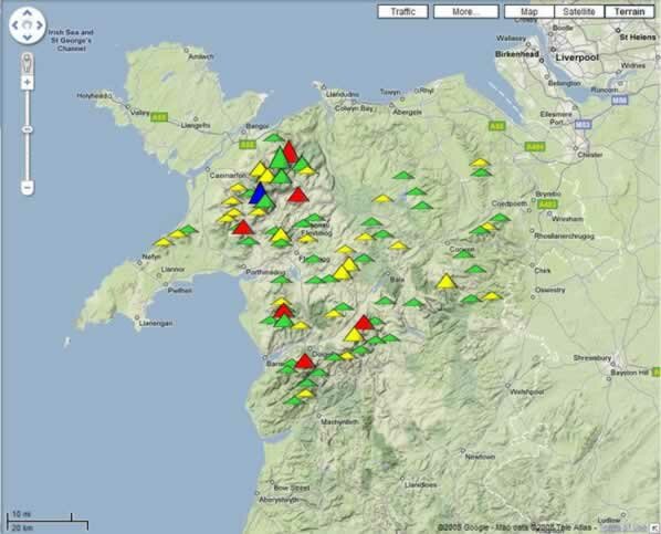
This shows all the 86 Prominent Peaks in North Wales with an appropriate icon (4 colours and 3 sizes) marking their position. This Google Map can be manipulated to zoom further in. The map can be moved across the screen by dragging with the mouse or using the direction arrows provided. The map is initially in ‘terrain’ form but you can change the view to ‘satellite’ or ‘map’. All 86 hills share the same map and you can find the one of particular interest to you by searching the list on the left (alphabetical order) or by clicking just above each icon.
More information on using these Google maps.
The second link to Streetmap is self-explanatory and unique for each hill.
This map comes up showing a 3 × 3 kilometre square, with the summit in the middle kilometre square as shown on the screenshot below.
Reproduced from Ordnance Survey map data by permission of Ordnance Survey, © Crown copyright.
The third link to Ordnance Survey Get-a-map comes up with a 2 × 2 km square centred at the summit.
Reproduced from Ordnance Survey map data by permission of Ordnance Survey, © Crown copyright.
Large area maps
It is quite useful to browse large areas with the Google Map facility. The following 3 links facilitate this.
For hills on the GB mainland south of Edinburgh/Glasgow together with the Isle of Man and Northern Ireland
For Ben Nevis and its descendants (Glasgow/Edinburgh to the Great Glen)
For Carn Eige’s descendants together with the Scottish Islands
© 2008 Google – Map Data © 2008 TeleAtlas
When the map first opens, many of the hill icons are not visible (see screenshot above); each map contains hundreds of symbols. If you zoom in significantly closer then all the hills in the area on view will appear. Again you can use the alphabetical listing to search your hill or click just above any icon. The resolution on the satellite images around Snowdon is impressive. Unfortunately the quality deteriorates in higher latitudes. See our guide to using Google maps for more information.
Local area maps
The 86 Prominent Peaks in Snowdonia in the screenshot towards the top of this page are included because they all fall in Region 30 (Sections 30A, 30B, 30C, 30D and 30E) as defined in Alan Dawson’s Relative Hills of Britain (The Marilyns). Regions 1 to 17 fit with the geographic boundaries established in Munr’os Tables by The Scottish Mountaineering Club. The Google Map links in the Database List Excel workbook take you to the hills of that Region. There are 3 exceptions. Regions 1 and 10 are split because of the large number of hills. Regions 38, 40 and 41 are combined as there are only 8 Prominent Peaks. By using this mechanism, restricting the number of icons to be loaded onto the map, all the hills appear without the necessity to zoom in further. There are 36 different local area maps, whereas the Region/ Section numbering goes up to 44. This is because there are a number of Regions which have no hills of 500 m elevation (Orkney, Shetland, St Kilda, River Tees to The Wash, Central & Eastern England and South-East England and the Isle of Wight).
To go to a local area map click on the area you would like on the map below.
© 2008 Google – Map Data © 2008 TeleAtlas
The individual maps are listed below:
| Map 1E |
Sections 1A (Loch Tay to Perth), 1B (Starthyre to Strathallan) & 1C (Cruach Ardrain & Ben Ledi families) |
| Map 1W |
Sections 1C (Ben Lomond and Ben Venue families) & 1D (Tyndrum hills, Arrochar alps and Luss hills). |
| Map 2 |
Sections 2A (Loch Rannoch to Glen Lyon and Bridge of Orchy hills), 2B (Ben Lawers and the Tamachans, Glen Lochay hills). |
| Map 3 |
Sections 3A (Glencoe north side), 3B (Glencoe south side, Beinn a'Bheithir, Loch Linhe to Loch Etive, Glen Creran) & 3C (Glen Etive to Glen Lochy, Blackmount). |
| Map 4 |
Sections 4A (Mamores, Ben Nevis, Aonachs, Grey Corries) & 4B (Rannoch Moor & Corrour, Ben Alder group, Loch Laggan). |
| Map 5 |
Sections 5A (Drumochter hills, 5B (Loch Ericht |
| Map 6 |
Sections 6A (Glen Tromie to Glen Tilt) 6B (Glen Tilt & Glen Geldie, Pitlochrie to Braemar & district, Glens Callater, Shee & Ey). |
| Map 7 |
Sections 7A (Braemar & district, Ballater & district, Glens Muick, Isla, Clova, Callater, Shee & Ey) & 7B (lower Grampians, Glens Clova & Esk). |
| Map 8 |
Sections 8A & 8B (Cairngorms) |
| Map 9 |
Sections 9A (Inverness to Strathspey) & 9B (Monadh Liath, Glen Roy to Creag Meaghaidh) |
| Map 10N |
Sections 10A (Arnisdale, Loch Quoich, South Glen Shiel) 10B (Knoydart, Glen Dessary) & 10C (Glen Moriston, Glen Garry, Clunes hills) |
| Map 10S |
Section 10D (Locheil, Glen Finnan, Morar) |
| Map 11 |
Sections 11A (Glen Affric, Inverinate, Kintail) & 11B (North Strath Cluanie, Glen Moriston). |
| Map 12 |
Sections 12A (Strathconon, Glen Carron, West Monar, Strathfarrar) & 12B (Glen Cannich, Killilan Forest). |
| Map 13 |
Sections 13A (Torridon) & 13B (Coulin, Applecross) |
| Map 14 |
Sections 14A (Loch Maree to Loch Broom) & 14B (The Fannaichs). |
| Map 15 |
Sections 15A (Inverlael & Strath Mulzie) & 15B (Ben Wyvis & Easter Ross). |
| Map 16 |
Sections 16B (Reay Forest, Ben Hope & Ben Loyal), 16C/D (E Sutherland & Caithness), 16E (Assynt) & 16F (Coigach) |
| Map 17 |
Sections 17A (Skye Trotternish), 17B (the Cuillin, Skye –Strathaird, Red Cuillin), 17C (Strataird, Sleat), 17D (Rum) & 17E (Mull) |
| Map 18 |
Sections 18A (Moidart, Ardnamurchan), 18B (Sunart, Ardgour) 18C (Kingairloch, Morvern) |
| Map 19 |
Sections 19B (Knapdale) & 19C (Ardgoil, Cowal) |
| Map 20 |
Section 20A (Jura) & 20C (Arran) |
| Map 21 |
Sections 21A (Tomintoul to Banff) & 21B (Fraserburgh to Dee Valley). |
| Map 22 |
Sections 24A (Lewis), 24B (North Harris) & 24C (South Uist) |
| Map 23 |
Section 26A (Ochil Hills, Campsie Fells) |
| Map 24 |
Sections 27A (Renfrewshire, Lanarkshire, Tinto Hills), 27B (Galloway Hills) & 27C (Carsphairn Hills, Dumfriesshire, Cumnock to Crawfordjohn, Lowther Hills) |
| Map 25 |
Sections 28A (Broughton Heights, Pentland Hills, Lammemuirs) & 28B (Manor Hills, Selkirkshire, Roxburgh, Ettrick Hills, Moffat Hills, Culter Hills) |
| Map 26 |
Section 29A (Isle of Man). |
| Map 27 |
Sections 30A (Lleyn Peninsular), 30B (Hebog, Snowdon, Glyders, Carneddau), 30C (Hiraethog, Clwydian Hills), 30D (Moelwyns, Arenigs, Rhinogs), 30E (Arans, Berwyns) & 30F (Cadair Idris). |
| Map 28 |
Sections 31A (Pumlumion), 31B (Radnor Forest) & 31C (Rhyader, Preseli) |
| Map 29 |
Sections 32A (Brecon Beacons, Black Mountains) & 32C (Brecon Beacons) |
| Map 30 |
Sections 33A (Cheviots, Kielder) |
| Map 31 |
Sections 34A (Lakes: N Fells), 34B (Lakes: W Fells, NW Fells) 34C (E Fells) & 34D (Lakes: S Fells) |
| Map 32 |
Sections 35A (North Pennines, Dales: N Fells, Howgills) & 35B (Dales: S Fells) |
| Map 33 |
Section 36A (Forest of Bowland, Lancashire, Peak District) |
| Map 34 |
Sections 38A (Long Mynd), 40A (Dartmoor) & 41A (Exmoor) |
| Map 35 |
Sections 43A (Cooley Mountains), Section 43B (Mourne Mountains, Co. Down) & 43C (Antrim Hills). |
| Map 36 |
Sections 44A (Co. Fermanagh) & 44B (Sperrin Mountains, Co. Tyrone) |